

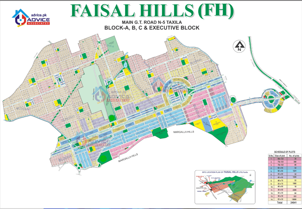
Understanding a housing society’s layout before you buy is one of the smartest moves any property buyer can make, and that’s exactly what the Faisal Hills Map is designed to help with. Whether you’re comparing block locations, checking access points, or trying to figure out which sector suits your budget, the map is your starting point for making sense of this large, master-planned community near Islamabad.
Faisal Hills sits along the main GT Road near Taxila, and its layout spans several distinct blocks — each with its own character, pricing, and development stage. In this guide, we’ll walk through the Faisal Hills Map in detail, covering every block, access route, and location advantage you need to know before booking a plot.
1. Understanding the Faisal Hills Map
The Faisal Hills Map is more than a simple layout diagram it’s a planning tool that shows exactly how the society is organized, from its main entrance on GT Road to the residential blocks tucked further inside. For buyers, studying the Faisal Hills Islamabad map before making a decision helps clarify which block offers the right balance of price, accessibility, and long-term growth potential.
Faisal Hills is developed by Faisal Town Group, formerly known as Zedem International, under the leadership of Chaudhry Abdul Majeed. The project received NOC approval from the Rawalpindi Development Authority (RDA) for over 11,800 kanals of land along the GT Road, giving it a strong legal foundation that’s clearly reflected across the official Faisal Hills Map.
Because the society is spread across multiple blocks rather than a single compact zone, the Faisal Hills Map becomes essential for anyone trying to compare locations before booking. A plot near the Executive Block behaves very differently — in terms of price, commercial activity, and access than a plot tucked into Block C or the newer Block D.
17. How to Read the Faisal Hills Map Before Buying a Plot
Most buyers look at the Faisal Hills Map simply to find a block or plot number. Smart buyers look beyond the boundaries and study what the location can mean for accessibility, lifestyle, development, and future resale value.
Before selecting a plot, look at five important things on the map: road access, surrounding development, nearby commercial areas, open spaces, and future connectivity.
A plot located close to a major boulevard may offer better accessibility, while a park-facing plot can be more attractive to families. Similarly, a corner plot may benefit from additional frontage, while an inner-street plot may offer a quieter residential environment.
This is why two plots of the same size can have completely different market values. The difference is often not the plot size it is the location within the society.
18. Main Boulevard vs Inner Street: Which Location Is Better?
One of the most useful things buyers can determine from the Faisal Hills Map is whether they prefer a main-road location or an inner residential street.
Main boulevard plots generally provide better visibility and accessibility, making them particularly attractive for commercial purposes and investors. Inner streets, on the other hand, can be more suitable for families who prioritize privacy and a quieter residential atmosphere.
| Location Type | Best Suited For | Main Advantage |
|---|---|---|
| Main Boulevard | Commercial & Investment | High visibility |
| Corner Plot | Residence & Investment | Additional frontage |
| Park Facing | Families | Open surroundings |
| Inner Street | Residential Living | Peaceful environment |
| Entrance Area | Commercial Buyers | Easy accessibility |
However, the most expensive location is not necessarily the best location for every buyer. Your choice should depend on whether your objective is living, rental income, commercial activity, or long-term appreciation.
19. How to Identify Future Growth Areas on the Faisal Hills Map
A particularly useful strategy for investors is to study not only developed areas but also the direction in which development is moving.
The Faisal Hills Map can help buyers identify potential growth areas by showing the relationship between existing blocks, road extensions, commercial zones, and major access routes.
Before considering an emerging area, investors should examine:
- New or expanding road networks
- Planned commercial areas
- Connections with major roads
- Nearby developed blocks
- Existing infrastructure
- Distance from major entrances
- Actual construction activity on the ground
A lower-priced plot in an undeveloped area should not automatically be considered a better investment. Growth potential becomes more meaningful when infrastructure, accessibility, demand, and surrounding development are moving in the same direction.
20. What the Faisal Hills Map Can Tell You About Resale Value
Plot size is only one part of a property’s future value. The exact position of a plot within the society can also influence its resale demand.
Locations that may attract stronger buyer interest can include:
- Corner plots
- Park-facing plots
- Main-road locations
- Wide-road plots
- Plots close to commercial areas
- Locations with developed surroundings
- Areas with better access to society entrances
For example, two 10 Marla plots may have the same dimensions but completely different market appeal if one is located near a developed boulevard while the other is situated in an early-stage area.
This makes the Faisal Hills Map particularly valuable for investors who are thinking beyond the initial purchase and considering the property’s future resale potential.
21. Master Plan vs Satellite View: Why Buyers Should Check Both
Another smart approach is to compare the Faisal Hills master plan with the actual surroundings visible through satellite imagery and, where possible, a physical site visit.
The master plan helps you understand the planned layout, including blocks, roads, commercial areas, and amenities. Satellite imagery can provide a broader visual understanding of existing construction and surrounding development. A site visit then allows you to verify the actual ground situation.
Ideally, buyers should use all three:
Master Plan → Understand the planned layout
Satellite View → Understand the surrounding area
Site Visit → Verify the actual ground reality
This simple process can help prevent buyers from making decisions based solely on marketing material or an outdated map.
22. The Faisal Hills Map 5-Minute Buyer Test
Before booking a plot, spend five minutes studying its exact position on the map and answer these questions:
1. Which entrance is closest to the plot?
2. How far is it from the main boulevard?
3. Where is the nearest commercial area?
4. Is it close to a park, mosque, school, or other planned facility?
5. How developed is the surrounding area?
6. What major roads provide access to this block?
If you can answer these questions clearly, you’re evaluating the property based on its actual location, rather than simply looking at its size and price.
23. The Best Faisal Hills Block Depends on Your Goal
There is no single block that can be called the best option for every buyer. The right choice depends on what you want to achieve from the property.
For Families
Families may prefer developed residential areas with easier access to parks, schools, mosques, utilities, and daily-use facilities. A peaceful inner street or park-facing plot may be more valuable to an end user than a main-road location.
For Investors
Investors may focus more heavily on entry price, development direction, road connectivity, demand, and potential resale opportunities. Emerging areas can offer greater upside but may also require a longer investment horizon.
For Commercial Buyers
Commercial buyers typically prioritize visibility, frontage, traffic flow, accessibility, and proximity to established commercial activity. For these buyers, the location shown on the Faisal Hills Map can be more important than the plot size itself.
This is why asking “Which is the best block in Faisal Hills?” is not enough. The better question is:
“Which block is best for my investment objective?”
24. Don’t Just Buy a Plot — Buy the Right Location
When purchasing property in a large housing society, buyers often focus on three things: price, plot size, and payment plan. These are important, but they don’t tell the complete story.
The Faisal Hills Map adds another crucial layer to the decision: where exactly is the property located?
A plot may have an attractive price, but if it is far from major access roads or surrounded by undeveloped land, its short-term usability may be limited. Another plot may cost more because it is closer to a boulevard, commercial zone, park, or developed neighborhood.
Ultimately, plot size tells you what you own, while the map tells you where you own it.
For this reason, buyers should study the latest Faisal Hills Map, verify the exact plot location, compare surrounding development, and visit the site before making a final booking decision.
2. Faisal Hills Islamabad Location Overview
Before diving into block-by-block details, it helps to understand the broader Faisal Hills Islamabad location. The society sits on the main GT Road (N-5) near Taxila, positioned between Islamabad and Rawalpindi, with the Margalla Hills forming a scenic backdrop along its northern edge.
This location places Faisal Hills within a genuinely useful middle ground:
- Close enough to Islamabad for a manageable daily commute via Margalla Avenue
- Directly on GT Road, making it accessible from both Rawalpindi and Taxila without detours
- Near the M-1 Motorway, connecting the society to Peshawar-bound and CPEC-related routes
- Quiet and removed from inner-city congestion, while still being commutable
Depending on the specific block and route taken, the drive into central Islamabad ranges from roughly 25 minutes via Margalla Avenue to closer to 40–50 minutes if traveling through denser city routes. This range is worth keeping in mind when comparing blocks on the Faisal Hills Map, since access time varies noticeably depending on which part of the society you’re looking at.
3. Faisal Hills Location Map: Roads and Access Points
The Faisal Hills location map highlights several key access routes that make the society easy to reach from multiple directions:
- GT Road (N-5): The main entrance sits directly on this road, with the Executive Block acting as the first point of contact for anyone approaching from Taxila or Rawalpindi.
- Margalla Avenue: This route significantly shortens the drive to Islamabad, making it the preferred path for daily commuters.
- M-1 Motorway: Connects the society to broader routes toward Peshawar and future CPEC-linked corridors.
- Islamabad Expressway connectivity: Offers an alternate path for residents heading toward eastern parts of the capital.
Multiple access points matter because they reduce dependency on a single route, which becomes especially important during peak traffic hours. When you study the Faisal Hills location map, you’ll notice that blocks closer to the main gate benefit from faster GT Road access, while inner blocks rely more heavily on the internal boulevard network.
4. Faisal Hills Master Plan Explained
The Faisal Hills master plan organizes the society into distinct functional zones — commercial frontage near the entrance, residential blocks further inside, and a few premium sectors positioned for higher visibility and easier access.
Key elements of the master plan include:
- A 225-feet-wide main boulevard connecting the major blocks
- Internal roads ranging from 40 feet to 110 feet depending on the block
- Designated areas for parks, mosques, schools, and community centers
- A mix of residential plot sizes from 5 Marla up to 2 Kanal
- Commercial zones concentrated primarily in the Executive Block and Prime Block
This kind of structured master planning is a big part of why Faisal Hills has continued attracting steady interest since its 2016 launch — buyers aren’t dealing with an unplanned patchwork of plots, but a genuinely organized layout that the Faisal Hills master plan lays out clearly from the start.
5. Faisal Hills Block Map: Executive Block
According to the Faisal Hills Executive Block map, this sector sits right at the main entrance on GT Road, making it the first block visible to anyone approaching the society. As the primary commercial hub, Executive Block includes:
- Direct GT Road frontage with no internal traffic congestion
- Commercial developments including Faisal Jewel and Faisal Mansion
- Roots International School Campus
- Residential plots ranging from 5 to 20 Marla alongside prime commercial plots
Because of its entrance-facing position, the Executive Block consistently commands premium pricing on the Faisal Hills Map compared to blocks positioned further inside. For buyers prioritizing visibility and immediate commercial access, this block is typically the first stop.
6. Faisal Hills Block Map: Block A
The Faisal Hills Block A map places this sector between the Executive Block and Block B, directly adjacent to the main GT Road. Block A is known for:
- A 225-foot main boulevard and street widths ranging from 40 to 110 feet
- A strong mix of residential and commercial plots
- The Arc Monument and Glow Garden as notable landmarks
- Nearly complete development, with construction well underway across most of the block
Block A has largely sold out in earlier phases, which reflects the strong demand tied to its central, GT Road-adjacent position on the Faisal Hills Map. Future plans also include a direct connection from Block A to GT Road, which would further strengthen its accessibility.
7. Faisal Hills Block Map: Block B and B Extension
Sitting to the west of Block A, the Faisal Hills Block B map shows a more residential character compared to the commercial intensity of the Executive Block and Block A. Block B features:
- Green spaces, parks, and scenic views of the Margalla Hills
- Educational institutions and grid stations
- Comparatively lower pricing than adjacent blocks, making it attractive for families on a budget
Within Block B lies Block B Extension, positioned near the block’s boundary close to a large graveyard. While B Extension’s planning is still evolving, it represents an area of potential future growth on the broader Faisal Hills development map, particularly as infrastructure continues to expand outward from the core blocks.
8. Faisal Hills Block Map: Block C
The Faisal Hills Block C map positions this sector further into the community, beyond Block B, with access via the main boulevard and connecting roads to Margalla Avenue. Block C stands out because of:
- Rising demand tied to its future connection with the CPEC route via the M-1 Motorway
- Competitive pricing relative to more developed blocks
- Ongoing infrastructure work, including partially completed road construction and operational water supply systems
For investors specifically looking at future development areas rather than immediate possession, Block C is frequently highlighted as one of the more promising sectors on the Faisal Hills Map, given its lower entry cost and improving connectivity.
9. Faisal Hills Block Map: Block D
As one of the newer additions to the society, the Faisal Hills Block D map shows this sector positioned next to Block C. Block D offers:
- Over 2,400 plots across various sizes
- Ongoing development work, including sewerage infrastructure
- Flexible payment plans, generally requiring a lower down payment with installments spread across several years
Because Block D launched more recently than the original four blocks, its pricing tends to sit lower on the Faisal Hills Map, which makes it a common entry point for buyers looking to invest early in a still-developing sector.
10. Faisal Hills Prime Block on the Map
The Faisal Hills Prime Block occupies a front-facing position with direct exposure to the main GT Road, connected closely to the Executive Block. Highlights of the Prime Block include:
- High visibility and strong commercial potential
- Proximity to Service Road East and Margalla Avenue
- Flexible booking terms, often including a 15% down payment with quarterly installments over four years
Given its prominent placement on the Faisal Hills Map, Prime Block has quickly become one of the most actively discussed sectors among both investors and end users looking for a strong combination of accessibility and future appreciation.
11. Faisal Hills Google Map Location: How to Find It
If you’re trying to locate the society digitally, the Faisal Hills Google map location can be found by simply searching “Faisal Hills Taxila” or “Faisal Hills Islamabad.” The pin drops directly along the N-5 highway, bordering the Margalla Hills.
Using the Google Maps view alongside the official Faisal Hills Map gives you a clearer sense of real-world distances — helpful for confirming drive times to specific landmarks, checking road conditions, or simply visualizing how far a particular block sits from the main entrance before scheduling a site visit.
12. Faisal Hills Map 2026: What’s Changed
The Faisal Hills map 2026 reflects several updates compared to earlier versions of the layout. Notable changes include:
- Expanded development activity in Block D, with sewerage and road infrastructure progressing steadily
- Increased commercial activity in the Executive Block, including new high-rise developments
- Continued progress on Block C’s connectivity improvements tied to the M-1 Motorway
- Growing interest in Prime Block due to its front-facing GT Road position
Because housing societies of this scale evolve continuously, it’s worth checking the latest Faisal Hills latest map directly with an authorized consultant before finalizing any purchase decision, since block boundaries and available inventory can shift as new sectors are released.
13. Faisal Hills Blocks Overview: Comparison Table
Here’s a simplified comparison to help you evaluate each block based on the current Faisal Hills Map:
| Block | Position | Best For | Development Stage |
| Executive Block | Main entrance, GT Road frontage | Commercial investment, visibility | Fully developed |
| Block A | Adjacent to GT Road, near Executive Block | Immediate construction, resale value | Nearly complete |
| Block B | West of Block A | Peaceful family living, lower cost | Developed |
| Block B Extension | Within Block B, near graveyard | Future growth potential | Early stage |
| Block C | Beyond Block B | Long-term investment, CPEC access | In progress |
| Block D | Next to Block C | Early-stage affordability | Development underway |
| Prime Block | Front-facing, near Executive Block | High visibility, commercial growth | Actively developing |
This kind of block-wise plot location comparison makes it much easier to match your goals — whether that’s immediate possession, long-term appreciation, or affordable entry — with the right section of the Faisal Hills Map.
14. Faisal Hills Development Map and Construction Progress
Tracking construction progress alongside the Faisal Hills development map gives buyers a realistic picture of what to expect after booking. As of recent updates:
- Executive Block has seen extensive construction, with the majority of its land already built on
- Block A is fully developed, with ongoing house construction
- Block B has completed road paving and leveling, with residents already living in the block
- Block C has completed earthwork, with road construction roughly halfway finished
- Block D remains in earlier development stages, with sewerage work currently underway
This progression matters because possession timelines vary significantly depending on which block you choose, and the Faisal Hills development map is the clearest way to track how close a particular sector is to being fully livable.
15. Faisal Hills Residential Map vs Commercial Zones
Not every block on the Faisal Hills residential map serves the same purpose. Broadly speaking:
- Commercial-heavy zones: Executive Block and Prime Block, both positioned near the GT Road entrance for maximum visibility
- Primarily residential zones: Block B and Block B Extension, offering quieter, family-oriented living
- Mixed-use zones: Block A, Block C, and Block D, which combine residential plots with pockets of commercial development
Understanding this distinction helps buyers avoid a common mistake — booking a residential plot in a zone that’s rapidly commercializing, or vice versa. Reviewing the residential and commercial breakdown on the Faisal Hills Map before booking helps set the right expectations for both lifestyle and future value.
16. Investment Potential Across the Faisal Hills Map
From an investment standpoint, different sections of the Faisal Hills Map offer different risk-and-reward profiles. Blocks closer to the GT Road entrance, such as the Executive Block and Prime Block, tend to carry higher upfront prices but also stronger commercial demand. Inner blocks like Block C and Block D typically offer lower entry costs with higher long-term appreciation potential as infrastructure matures.
It’s also worth noting the broader competitive landscape. When comparing Faisal Hills to other Faisal Town Group developments — including Faisal Town Phase 2 near Thalian Interchange — many investors weigh factors like NOC-approved housing society status, proximity to motorways, and overall master planning quality before deciding which project fits their portfolio. Faisal Hills’ position along GT Road and its M-1 Motorway access give it a distinct profile compared to Faisal Town Phase 2’s M-2 Motorway-facing location, and understanding this difference through both projects’ maps helps investors diversify more intentionally.
Taxila Islamabad real estate has generally trended upward as connectivity along GT Road and the M-1 corridor continues to improve, which further supports the long-term case for blocks positioned toward the outer edges of the current Faisal Hills Map.
Studying the Faisal Hills Map before making any booking decision gives you a clear, practical understanding of what each block actually offers — from the commercial energy of the Executive Block and Prime Block to the quieter, family-oriented layout of Block B, and the emerging investment potential of Block C and Block D. Every sector on the Faisal Hills Islamabad map serves a different purpose, and knowing these differences helps you choose a plot that genuinely matches your goals, whether that’s immediate possession, long-term appreciation, or commercial visibility.
As the society continues developing along GT Road near Taxila, referring back to the latest Faisal Hills Map remains the most reliable way to track new block launches, construction progress, and shifting investment opportunities across this well-established housing project.
Call to Action
Thinking about booking a plot based on what you’ve seen on the Faisal Hills Map? Reach out to a verified Faisal Hills consultant today to confirm current block availability, payment plans, and site visit options before making your decision.